DEDHAM, Mass. — A messy winter storm packing snow, ice, and rain is heading to Massachusetts, threatening to disrupt midweek travel before another round of unsettling weather arrives over the weekend.
The Boston 25 Weather team is closely tracking a system that could bring up to 5 inches of snow and icy driving conditions on Thursday before an eventual flip to rain in some places.
“The timeline on that snow has it moving in mid-to-late morning, so I’m thinking around 10 a.m. it gets into the Boston area and gets heavy,” Boston 25 Meteorologist Shiri Spear said in her latest forecast. “Some of the worst travel conditions are late morning into the afternoon.”
Ice will fill in from western Massachusetts to Worcester to Boston by around 3 p.m., pushing the plain snow line up to the Massachusetts-New Hampshire border.
“Thursday we’re going to have to be real careful out there,” Spear warned drivers.
The changeover to rain down across southeastern Massachusetts will slowly push north for the evening commute, but the threat of the wintry mix and ice might remain for parts of central and northern Massachusetts.
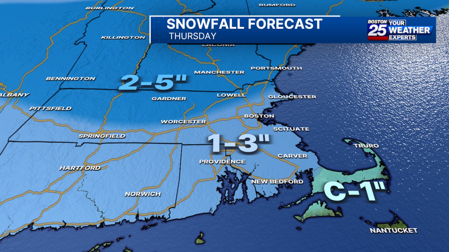
Two to 5 inches of snow is on tap for parts of western, central, and northern Massachusetts. One to 3 inches of snow is expected for eastern Massachusetts, including Boston, the South Shore, and parts of the North Shore. Cape Cod and the Islands will see a coating to 1 inch of snow.
Another storm is expected on Saturday night into Sunday morning, Spear said, but it’s too early to pinpoint the exact details at this time.
“The bulk of the precipitation looks to come through overnight with snow changing to a mix or even rain by Sunday morning,” Spear wrote in her latest weather blog.
To stay up to date with the latest forecast, visit the Boston 25 Weather page.
Download the FREE Boston 25 News app for breaking news alerts.
Follow Boston 25 News on Facebook and Twitter. | Watch Boston 25 News NOW
©2025 Cox Media Group
/cloudfront-us-east-1.images.arcpublishing.com/cmg/7QOJU3BNCJERBNKJC5LWTBYFLU.png)


